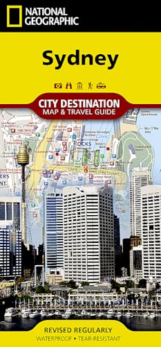
Sydney Map (National Geographic Destination City Map)
Product Description
Sydney Map (National Geographic Destination City Map)
<b>• Waterproof • Tear-Resistant • Travel Map</b></p><p>Explore the vibrant urban life, culture, and natural beauty of Sydney with National Geographic's City Destination map. A detailed street map and inset of Sydney Harbour is featured on the front side of this comprehensive map. Transportation decisions in and around the city are made easier with the inclusion of ferry stops and CityRail, light rail, monorail, and Sydney Explorer stations. Hundreds of points of interest, places of worship, parks, notable buildings, pedestrian areas, hotels, theaters, and more are noted. </p><p>The reverse side of the map has both a regional map and a diagram of the Sydney Airport. Unlike many city maps, this one also acts as a travel guide with information about points of interest, sites to visit around Sydney, and the many public transportation options. The CityRail map will prove particularly helpful to visitors wishing to travel to most attractions in the city as well as surrounding suburbs.</p><p>Every Destination Map is printed on durable synthetic paper, making them waterproof, tear-resistant and tough — capable of withstanding the rigors of any kind of travel.</p><i><ul><li>Map Scale = 1:12,750</li><li>Sheet Size = 24.75" x 17.75"</li><li>Folded Size = 4" x 8.75"</li></ul></i>
Technical Specifications
You might also like

New Zealand (National Geographic Adventure Map)

Australia (National Geographic Adventure Map)

Fodor's Essential Australia (Full-color Travel Guide)

Melbourne Australia 1:12,500 Travel Map

Lonely Planet Sydney City Map

Top 10 Sydney (Pocket Travel Guide)
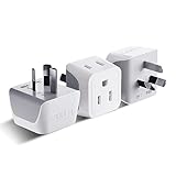
Australia, New Zealand, China Travel Adapter Plug by Ceptics with Dual USA Input - Type I (3 Pack) - Ultra Compact - Safe Grounded Perfect for Cell Phones, Laptops, Camera Chargers and More (CT-16)

DK Eyewitness Travel Guide Sydney

Lonely Planet Sydney (Travel Guide)

Australia East (National Geographic Adventure Map)