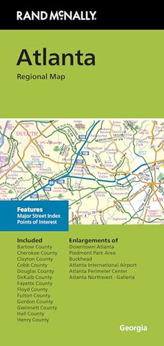
Rand McNally Folded Map: Atlanta Regional Map
Product Description
Rand McNally Folded Map: Atlanta Regional Map
- Regularly updated, full-color maps
- Clearly labeled Interstate, U.S., state, and county highways
- Indications of parks, points of interest, airports, county boundaries, schools, shopping malls, downtown & vicinity maps
- Easy-to-use legend
- Copyright 2024
- Coverage Area Communities Included: Bartow County, Chereokee County, Clayton County, Cobb County, Douglas County, DeKalb County, Fayette County, Floyd County, Fulton County, Gordon County, Gwinett County, Hall County, Henry County
Technical Specifications
You might also like

Boys Outfits Toddler Boys Shorts Summer Shorts Casual Outwear Fashion for Children Clothes Outwear (Grey, 4-5 Years)
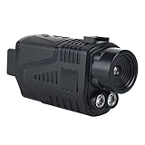
BouPower 1.5 Inch Screen Digital Night Vision, 5X Digital Zoom Night Vision Goggles for Adults, 7 Level Adjustable Infrared Thermal Vision for Camping Travel Hunting

ZzzQuil Nighttime Sleep Aid Liquicaps, 48 Count
Replacement Earbuds Tips Silicone Ear Tips Compatible with Bose New QuietComfort Earbuds, Earphones Eartips Earpads Ear Caps S/M/L 3 Size 6 Pairs,White 803w

Full Shine Clip in Hair Extensions Human Hair Dark Blonde Mix Light Blonde Seamless Hair Extension Clip ins PU Weft for Women 20 Inch 8 Pcs 120g

My Wild Garden: Notes from a Writer's Eden

Dazzle Dust Edible Glitter Sprinkles for Cake Decorating, Drinks, Cookie, Icing, Dessert Decorations, Sparkly Luster, Food-Grade, Vegan, Gluten Free, Kosher, Bulk 10g, Silver

BREVELTION 110V Full Stainless Steel Linear Vibrating Screen Industrial Vibrating Screen Electric Linear Screening Machine for Screening Powder Plastic Particles Grains with 5mm Screen 80W