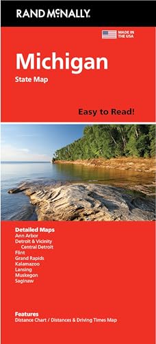
Rand McNally Easy to Read: Michigan State Map
Product Description
Rand McNally Easy to Read: Michigan State Map
- Regularly updated, full-color maps
- 45% larger map with a bigger type size than the Rand McNally Folded Map
- Clearly labeled Interstate, U.S., state, and county highways
- Indications of county boundaries, schools, shopping malls, parks, golf courses, hospitals, airports, and points of interest
- Mileage and driving times map
- Detailed index
- Copyright 2024
- Coverage Area Detailed maps of: Ann Arbor, Detroit & Vicinity, Downtown Detroit, Flint, Grand Rapids, Kalamazoo, Lansing, Muskegon, Saginaw
Technical Specifications
You might also like

Little Me Quick Dry Baby/Toddler Girls Sun Hat for Swimming and Sun Protection
—

Toddler Boys Ripped Denim Shorts Fashion Distressed Jean Shorts Kids Loose Fit Wide Leg Elastic (Blue, 18-24 Months)
—

Toddler Kids Denim Cargo Shorts Casual Elastic Waist Comfy Summer Loose Jean Shorts for 2-12 Years
—
5 Pairs of Boys Shorts,Summer Casual Fashion Toddler Shorts,Boys Girls Cotton Casual Pants (US, Numeric, 25, Pink)
—

innewgogo Leopard Fashion Black Toddler Baby Boy Girl Cotton Pull-On Shorts Elastic Waist Athletic Casual Shorts Kids Pants 2T
—

Kids Wide Leg Cargo Shorts Knee Length Baggy Summer Casual Elastic Waist Bermuda Shorts with Pockets for 5-15 Years
—

Victoria's Secret Pink with Splash Fresh & Clean All-Over Body Mist 75ml / 2.5 Fl OZ
—

Kids Gradient Beach Shorts Loose Elastic Waist Summer Casual Knee Length Shorts with Pockets for 6-14 Years
—