
Rand McNally Easy to Read: Colorado State Map

Product Description
Rand McNally Easy to Read: Colorado State Map
- Detail maps of major cities, a mileage chart, and a Mileages & Driving Times Map
- Regularly updated, Full-color maps
- Clearly labeled Interstate, U.S., state, and county highways
- Indications of county boundaries, schools, shopping malls, parks, golf courses, hospitals, airports, and points of interest
- Detailed index
- Copyright 2021
- Coverage Area Detailed maps of: Boulder, Colorado Springs, Denver & Vicinity, Downtown Denver, Fort Collins, Greeley, Mesa Verde National Park, Pueblo, Rocky Mountain National Park
Technical Specifications
You might also like

Safety Technology International, Inc. STI-6400 Exit Stopper Multifunction Door Alarm, Helps Prevent Unauthorized Exits or Entries Through Emergency Doors 2 Pack
—
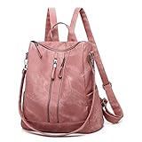
ROOSALANCE Backpack Purse for Women, Women Backpack Purse Small Leather Waterproof Anti-theft Shoulder Bags Handbags, Fashion Ladies Backpack for Daily Travel Work
—

CORIOS Elegant Handbag for Women PU Leather Shoulder Crossbody Bag Fashion Messenger Top-Handle Bag Small Hobo Satchel Bag Shopping Travel Office Tote Khaki
—

Neer 3 Pack Men's Big and Tall Waffle Thermal Long Sleeve Shirts V Neck Tops Casual Pullover Knit Undershirt with Pockets(Black, Dark Gray, Navy Blue,XX-Large)
—
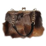
Luxurious Fashion Natural Fox Fur with Hair Handbag for Women and Ladies (FireFox)
—

August Alley 5 Pack Thermal Long Sleeve Shirts for Men V Neck Fleece T Shirt Loose Fit Base Layer Sweatshirts Cold Weather(Matcha Green, Light Blue Gray, Dusty Rose, Black, Blue,Small)
—

YALIZHNA Womens Backpack Purse Fashion Pu Leather Anti-theft Large Travel Backpack Ladies Shoulder Bags Satchel Handbag (Coffee)
—

August Alley 3 Pack Men's Waffle Long Sleeve Baseball Shirts Blend Raglan Tops Casual Jersey Color Vintage Sport Tees(Black/White, Dark Gray/White, Army Green/White,Large)
—