
Easy To Read: Alabama State Map
Product Description
Easy To Read: Alabama State Map
- Regularly updated, full-color maps
- 68% larger map with a bigger type size than the Rand McNally Folded Map
- Clearly labeled Interstate, U.S., state, and county highways
- Indications of parks, points of interest, airports, county boundaries, and more
- Mileage and driving times map
- Detailed index
- Convenient folded size
- Copyright 2016
Rand McNally's Easy To Read State Folded Map is a must-have for anyone traveling in and around Alabama, offering unbeatable accuracy and reliability at a great price. Our trusted cartography shows all Interstate, U.S., state, and county highways, along with clearly indicated parks, points of interest, airports, county boundaries, and streets.<br><br>The easy-to-use legend and detailed index make for quick and easy location of destinations. You'll see why Rand McNally folded maps have been the trusted standard for years.<br><br> Regularly updated, full-color maps<br> 68% larger map with a bigger type size than the Rand McNally Folded Map<br> Clearly labeled Interstate, U.S., state, and county highways<br> Indications of parks, points of interest, airports, county boundaries, and more<br> Mileage and driving times map<br> Detailed index<br> Convenient folded size<br><br><br>Coverage Area<br><br>Detailed maps of: Auburn/Opelika, Birmingham, Dothan, Florence, Huntsville, Mobile, Montgomery, Phenix City/Columbus, GA, Tuscaloosa
Technical Specifications
You might also like

Traveler's Guide to Alaskan Camping: Alaskan and Yukon Camping with RV or Tent (Traveler's Guide series)

The MILEPOST 2019: Alaska Travel Planner

Fodor's Alaska (Full-color Travel Guide)

Moon Anchorage, Denali & the Kenai Peninsula (Travel Guide)

Easy to Read!: Illinois State Map

Easy To Read: Georgia State Map (Rand McNally Easy to Read!)
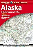
Delorme Alaska Atlas and Gazetteer

Easy To Read: Arkansas State Map (Rand McNally Easy to Read!)

Easy To Read: New York State Map (Rand McNally Easy to Read!)

British Columbia, Road Map