
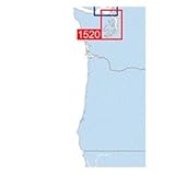
MAPTECH Waterproof Chart Kit San Juan Islands
Product Description
MAPTECH Waterproof Chart Kit San Juan Islands
Detailed coverage of Whidbey Island and Bellingham to Boundary Pass. 23 chart pages, GPS waypoints, Lat./Long. grids, courses, Anchorages, ramps, and marinas. 12" x 17"
Technical Specifications
You might also like

A Cruising Guide to Puget Sound and the San Juan Islands: Olympia to Port Angeles (International Marine-RMP)
—
Maptech Waterproof Chart Kit - Puget Sound
—

2017 Waggoner Cruising Guide
—

U.S. Chart No. 1: Symbols, Abbreviations and Terms used on Paper and Electronic Navigational Charts, 12th edition
—

San Juan Islands Cruise Guide: A Boaters Handbook for Camping the San Juan's and Surrounding Area - Expanded Edition (Volume 2)
—
Navigation Rules and Regulations Handbook
—

Current Atlas: Juan de Fuca Strait to Strait of Georgia
—

Exploring the San Juan & Gulf Islands: Cruising Paradise of the Pacific Northwest
—