
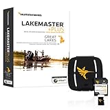
Humminbird 600023-8 LakeMaster Southeast States V5 Electronic Chart
Product Description
Humminbird 600023-8 LakeMaster Southeast States V5 Electronic Chart
- Maximize every moment of fishing when you upgrade to the unrivaled accuracy and detail of Humminbird LakeMaster mapping, which features easy-to-read contours, highlighted depth ranges, and scrollable lake lists.
- This Southeast States Edition, Version 5 boasts 300 high-definition lakes and more than 760 total lakes from AL, FL, GA, KY, MS, and TN, adding over 230 new lakes since the prior version (260 in high definition).
- Easy-to-see shading highlights shallow-water areas within an adjustable range up to 30 feet, and depth contours and shorelines can be synchronized with the actual water levels of lakes, reservoirs, and rivers.
- LakeMaster digital maps can be used with Minn Kota i-Pilot Link (sold separately), allowing you to follow a selected depth contour line to deliver precise, automatic boat control.
- LakeMaster digital maps come on a Micro SD card (with included SD card adapter) that's compatible with all GPS-equipped HELIX, SOLIX, ONIX, and ION Series models and select 600-1100 Series models.
Maximize every moment of fishing when you upgrade to the unrivaled accuracy and detail of Humminbird LakeMaster mapping, which features easy-to-read contours, highlighted depth ranges, and scrollable lake lists. LakeMaster digital maps provide the most detailed, high-definition collection of freshwater mapping in the United States, with unmatched depth contours between 1-3 feet (in high definition) or 3-5 feet (standard definition). This Southeast States Edition, Version 5 boasts 300 high-definition lakes and more than 760 total lakes from AL, FL, GA, KY, MS, and TN, adding over 230 new lakes since the prior version (260 in high definition). New high-definition lake map data includes Dale Hollow, Green River, Martin, Sidney Lanier, Watts Barr, Weiss, and more. Easy-to-see shading highlights shallow-water areas within an adjustable range up to 30 feet, and depth contours and shorelines can be synchronized with the actual water levels of lakes, reservoirs, and rivers. LakeMaster digital maps can be used with Minn Kota i-Pilot Link (sold separately), allowing you to follow a selected depth contour line to deliver precise, automatic boat control. Collected by Humminbird's own team of GIS analyst cartographers, LakeMaster high-definition maps are created from on-the-water surveys using hundreds of thousands of depth soundings, plus state-of-the-art GPS and sonar technologies. LakeMaster digital maps come on a Micro SD card (with included SD card adapter) that's compatible with all GPS-equipped HELIX, SOLIX, ONIX, and ION Series models and select 600-1100 Series models. Strictly intended for use in your Humminbird GPS unit, LakeMaster mapping cards are not PC compatible and map files could be corrupted if accessed on a computer.
Technical Specifications
You might also like

Humminbird 720074-1 AS EC QDE 700 Series Ethernet Adapter Cable

Minn Kota 1852085 Black Standard Helix Accessory,Fishfinder, humminbird, Sonar, Adapter Cable
Humminbird Suncover Humminbird 780036-1 Suncover, Helix 7, Black

RAM Drill-Down Double Ball Mount for Humminbird Helix 7

Humminbird 720073-2 AS EC 10E Ethernet Cable (10 Feet)

MinnKota US2 Adaptor Cable for Humminbird 7 Pin
T-H Marine GFTJ-1-DP G-Force Jacket Trolling Motor Cable Organizer Sleeve
Humminbird LakeMaster Great Lakes Edition Digital GPS Lake Maps, Micro SD Card, Version 4

Humminbird 780038-1 Humminbird 780038-1 UC H89 Unit Cover for Humminbird HELIX 8 and HELIX 9 G3N Model Fishfinders
VMC, Neko Weights, 1/8 oz, Natural, Package of 10