
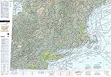
FAA Chart: U.S. VFR Wall Planning Chart (Folded) VFRWPC (Current Edition

Product Description
FAA Chart: U.S. VFR Wall Planning Chart (Folded) VFRWPC (Current Edition
- Now shipping current edition: DEC 05 2020
- Next Effective Date: DEC 02 2021
- High quality paper and print - Folded
- Always in stock at Ruby & Rudy's Books
This aeronautical flight map is used for air navigation and route planning. Print area is 42 inches by 60 inches. This chart is updated once every 2 years.
Technical Specifications
You might also like

FAA Chart: VFR Sectional SEATTLE SSEA (Current Edition)

FAA Chart: VFR Sectional DALLAS SDAL (Current Edition)

FAA Chart: VFR Sectional SAN FRANCISCO SSF (Current Edition)

FAR/AIM 2020: Federal Aviation Regulations/Aeronautical Information Manual (FAR/AIM Series)
FAA Chart: VFR Sectional NEW YORK SNY (Current Edition)

ASAs Color E6B Flight Computer

FAA Chart: VFR Sectional PHOENIX SPHX (Current Edition)

FAA Chart: VFR Sectional HOUSTON SHOU (Current Edition)

FAA Chart: VFR Sectional KLAMATH FALLS SKF (Current Edition)

FAR/AIM 2019: Federal Aviation Regulations / Aeronautical Information Manual (FAR/AIM Series)